

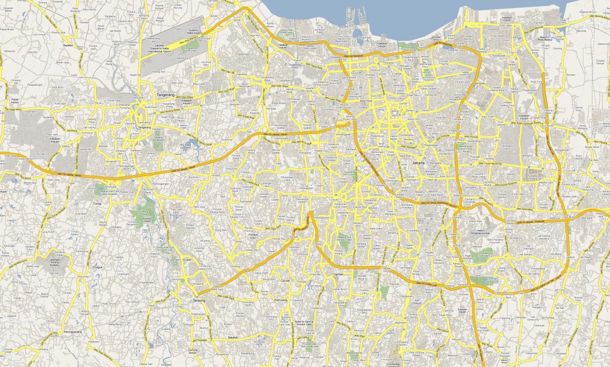
You can find on this page the Jakarta streets map to print and to download in PDF. The Jakarta roads map presents the road network, main roads, routes and motorways of Jakarta in Java - Indonesia.

The Jakarta streets map shows all street network and main roads of Jakarta. This streets map of Jakarta will allow you to find your routes through the streets of Jakarta in Java - Indonesia. The Jakarta streets map is downloadable in PDF, printable and free.
Jendral Sudirman Sudirman or better known as Jalan Sudirman is one of the main streets in Jakarta. It is located between the West and the Central City of Jakarta as you can see in Jakarta streets map, that makes this road seems so busy. Various office and economic activities are spinning rapidly here. There aee also various supporting facilities such as office buildings, shopping centers, entertainment centers, as well as various apartments in Sudirman become a sign of the bustle and development of this one area. Sudirman also refers to the central business district or so-called Financial District. Muhammad Husni Thamrin street or known as Jalan Thamrin is the name of one of the main streets of Jakarta. It is also the largest Business Center in Indonesia. In addition, every Sunday morning the road is also closed for vehicles for the Car Free Day area.
Jalan Jaksa is a 400 meter short street in Central Jakarta as its shown in Jakarta streets map. Initially, this road has existed since the Dutch era, when students of Rechts Hogeschool Batavia (Jakarta Legal Academy) settled here while studying. Jalan Jaksa is increasingly recognized by foreign tourists for entering and being recorded in well-known travel guides such as Lonely Planet. Jalan Taman Fatahillah also became one of the most famous street in Jakarta precisely in West Jakarta. On this street there is Kota Tua area which became one of the tourist bersajarah in Indonesia. The Kota Tua is a tourist place that contains a lot of history and contains a lot of knowledge. There are many museums you can visit such as the Fatahillah Museum, Sunda Kelapa Harbor, Bank Indonesia Museum, and the Museum of Ceramics.
Sabang is a street name in central Jakarta that has long been known as a hangout center and culinary center. Year after year, the residents of Sabang also alternately come and go. But still quite a lot that still exist in this increasingly heavy competition arena. Surabaya street as its mentioned in Jakarta streets map is not a street in Surabaya, it is one of the most popular street in Jakarta. Located in Jakarta luxury residential area, the stalls are crowded with various ancient objects, handbags and luggage imported second hand lined on Jalan Surabaya, Menteng, Jakarta.Letaknya strategic, in the office area, making the Road Surabaya is also quite easy to reach.
The Jakarta roads map shows all road network and highways of Jakarta. This roads map of Jakarta will allow you to find your routes through the roads and motorways of Jakarta in Java - Indonesia. The Jakarta roads map is downloadable in PDF, printable and free.
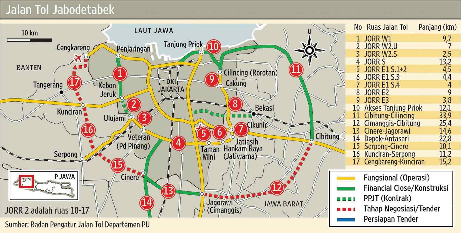
A structured road network had been developed in the early 19th century as a part of the Java Great Post Road by Daendels, which connects most major cities throughout Java. During the following decades, the road network was expanded to a great extent, although it could not keep up with the rapidly increasing numbers of motorized vehicles, resulting in highly congested traffic. A notable feature of Jakarta present road system is the toll road network. Composed of an inner and outer ring road and five toll roads radiating outwards as you can see in Jakarta roads map, the network provides inner as well as outer city connections. The outer ring road is under construction, but it is largely in use. While 6 Jakarta Elevated Toll Roads are still in tender progress.
The five radiating toll roads are the: Prof. Dr. Sedyatmo Toll Road linking to Soekarno-Hatta International Airport, Jakarta-Tangerang Toll Road linking to Tangerang and further to Merak in the west, Jakarta-Serpong Toll Road linking to Serpong, Jagorawi Toll Road linking to Bogor and Ciawi in the south Jakarta-Cikampek Toll Road linking to Bekasi and Cikampek in the east as its shown in Jakarta roads map. Throughout the years, several attempts have been made to reduce traffic congestion on Jakarta main arteries. Implemented solutions include a 'three-in-one' rush-hour law, during which cars with fewer than three passengers are prohibited from driving on the main avenues. Another example is the ban on trucks passing main avenues during the day.
Despite the presence of many wide roads, Jakarta suffers from congestion due to heavy traffic, especially in the central business district as its mentioned in Jakarta roads map. To reduce traffic jams, some major roads in Jakarta have a 'three in one' rule during rush hours, first introduced in 1992, prohibiting less than three passengers per car on certain roads. In 2005, this rule covered the Gatot Subroto Road. This ruling has presented an economic opportunity for "joki" (meaning "jockey"), who wait at the entry points to restricted areas and charge a fee to sit in cars which have only one or two occupants while they drive through. Jakarta roads are notorious for the undisciplined behavior of drivers; the rules of the road are broken with impunity and police bribery is commonplace.