
: failed to open stream: HTTP request failed! HTTP/1.1 503 Service Unavailable
in <b>/home/servuzmq/minisites/siteT1/common/template/carteV2.php</b> on line <b>139</b><br />
)
You can find on this page the Jakarta airports map to print and to download in PDF. The Jakarta airport map presents terminals and gates of the international airport of Jakarta in Java - Indonesia.
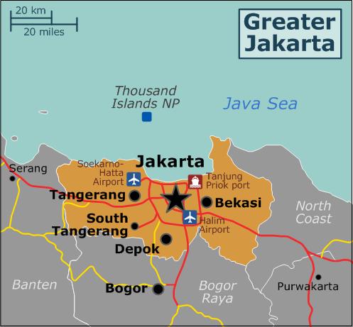
The Jakarta airports map shows all the airports around Jakarta. This airports map of Jakarta will allow you to determine which airport you will used to leave Jakarta in Java - Indonesia. The Jakarta airports map is downloadable in PDF, printable and free.
Soekarno-Hatta International Airport, the airport is approximately 20 Km northwest of Jakarta, accessible by the toll road. From Jalan Jenderal Sudirman in the city centre, take the inner city toll road (Jalan Tol Dalam Kota), continue on the Pluit-Tomang toll road, following to Kapuk Muara as you can see in Jakarta airports map. Take the toll road, called Jalan Tol Prof. Sedyatmo, continuing directly to the Airport toll road. There are three terminals: Terminal 1 caters to domestic flights only. Terminal 2 serves primarily international and some domestic flights. Terminal 3 serves domestic and international flights of selected, primarily budget, carriers.
Halim Perdanakusuma Airport, the airport is approximately 12 Km from the Semanggi interchange in central Jakarta as its shown in Jakarta airports map. From Jalan Jenderal Sudirman, follow directions to Jalan Jend. Gatot Subroto, preferably using the inner city toll road (Jalan Tol Dalam Kota). Exit at Cawang towards Jatinegara, continue on Jalan MT Haryono, stay right and take Jalan Halim Perdanakusuma, turning left before the Pertamina depot to Jalan Rajawali Baru, following directions to Jalan Runway in front of the airport terminal. Currently the airport is only open to domestic flights for certain airlines, as well as to several charter airline services and for private airplanes and government, military or police use.
International airports near Jakarta as its mentioned in Jakarta airports map: 31 km: Jakarta, Indonesia (CGK / WIII) Soekarno-Hatta International Airport, 153 km: Bandung, Indonesia (BDO / WICC) Husein Sastranegara International Airport, 455 km: Semarang, Indonesia (SRG / WARS) Achmad Yani International Airport. Domestic airports near Jakarta: 31 km: Jakarta, Indonesia (CGK / WIII) Soekarno-Hatta International Airport, 153 km: Bandung, Indonesia (BDO / WICC) Husein Sastranegara International Airport, 256 km: Bandar Lampung, Indonesia (TKG / WIAT) Radin Inten II Airport. Local airports near Jakarta: 6 km: Djakarta, Indonesia (JKT) Kamayoran International, 23 km: Jakarta, Indonesia (HLP / WIIH) Halim Perdanakusuma International Airport, 23 km: Ciputat, Indonesia (PCB / WIHP) Pondok Cabe Airport.
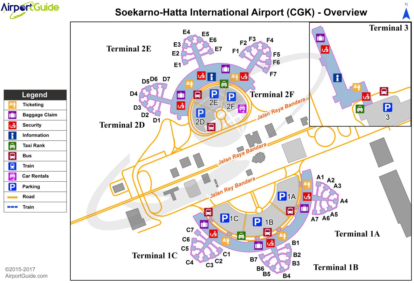
The map of Jakarta airport presents the main international airport of Jakarta. This international airport map of Jakarta will allow you to determine by which terminal and gate you will arrive or leave Jakarta in Java - Indonesia. The airport Jakarta map is downloadable in PDF, printable and free.
Soekarno–Hatta International Airport (Indonesian: Bandar Udara Internasional Soekarno–Hatta) (IATA: CGK, ICAO: WIII), abbreviated SHIA or Soetta is the main airport serving the greater Jakarta area on the island of Java, Indonesia as you can see in Jakarta international airport map. The airport is named after the first President of Indonesia, Soekarno, and the first vice-president, Mohammad Hatta. The airport IATA code, CGK, originates from Cengkareng, a district northwest of the city, and it is often called Cengkareng Airport by Indonesians. Located about 20 km west of Jakarta, in Tangerang, Banten, Soekarno–Hatta Airport began to operate in 1985, replacing the former Kemayoran Airport (domestic flights) in Central Jakarta, and Halim Perdanakusuma International Airport in East Jakarta. Kemayoran Airport has since transformed into public areas. Halim Perdanakusuma is still operating, serving mostly VVIP, charters and military flights. Terminal 2 opened in 1992 and Terminal 3 opened in 2009, but in 2010 total passengers reached 43.7 million, surpassing the 38-million passenger capacity of all 3 terminals.
In May 2008, ForbesTraveller.com recognized Soekarno–Hatta International Airport as the 6th most punctual airport in the world with 86.3% of its flights departing on time, while 72.3% arriving on time. In December 2009, ForbesTraveller.com recognized Soekarno–Hatta International Airport as the 2nd most punctual airport in the world with 89.2% of its flights departing on time, and 84.2% arriving ontime as its shown in Jakarta international airport map. In 2011, the airport was the 12th busiest airport in the world with 51.1 million passengers, increasing by some 8 millon or 18.5 percent from 2010. Although the airport is running overcrowded, on May 4, 2012 Airport Council International (ACI) after verification from April 23 to May 3 has stated Soekarno-Hatta International Airport is clearly safe operate. All safety flying procedure is running well.
The land area of the airport is 18 km² as its mentioned in Jakarta international airport map. It has two independent parallel 2,400-meter runways connected by two cross taxiways. There are three main terminal buildings; Terminal 1 (domestic flights only), Terminal 2 (international flights and Garuda Airlines domestic flights) and Terminal 3, Pier 1 (Air Asia international and domestic flights). There is also a freight terminal for domestic and international cargo. Soekarno–Hatta International Airport has 180 check-in counters, 36 baggage carousels and 45 gates. Sub-terminals 1A-1B-1C-2D-2E-2F have 25 check-in counters, 5 baggage carousels and 7 gates every sub-terminals. Terminal 3 has 30 check-in counters, 6 baggage carousels and 3 gates. The freight terminal is located in the east-side of terminal 1. This terminal was used to handle cargo at the Soekarno–Hatta International Airport, both domestic and international cargo. In the newest masterplan, the freight terminal will move to the west-side of terminal 2 with larger capacity than the current terminal.