

You can find on this page the Jakarta neighborhood map to print and to download in PDF. The Jakarta districts map presents quarters, region, suburbs and surrounding area of Jakarta in Java - Indonesia.

The Jakarta neighborhoods map shows region and suburbs of Jakarta areas. This neighborhood map of Jakarta will allow you to discover quarters and surrounding area of Jakarta in Java - Indonesia. The Jakarta quarters map is downloadable in PDF, printable and free.
Kemang, this neighborhood in South Jakarta is the city most fashionable district, its streets lined up with the city best fashion boutiques, from local labels to imported, limited items. Kemang is also packed with modern, youthful restaurants and cafés with creative, artsy concepts. One of the oldest and most prestigious neighborhoods in Jakarta, Menteng as its shown in Jakarta neighborhoods map has the city most elegant buildings, from restaurants to houses. Menteng hosts the residence of many Indonesian governments and high-ranking officials, as well as legendary restaurants that highlight fine, authentic Indonesian cuisine. Glodok is Jakarta Chinatown, hosting a great deal of the city Chinese population. Consequently, the area throbs in a different way than the rest of the city. The neighborhood is dense with stores, many of which have been in business for generations.
Sudirman-Thamrin as you can see in Jakarta neighborhoods map is one of the city most prominent business centers, this neighborhood contributes greatly to Jakarta ever-growing skyline, with tall stylish buildings that host hundreds of businesses. Not only known as a business district, this area is as lively at night as it is all day as vibrant bars and clubs in the neighborhood transform it into a youthful nightlife hub. Once serving as the center of governmental activities in Dutch colonial times, many of the historical, centuries-old buildings still stand in the neighborhood today. Kota Tua Jakarta is now a popular tourist attraction where tourists come to observe stylish European-style buildings, enjoy the open air, dine at colonial-inspired restaurants, and do other activities. Some of the old buildings have been repurposed and reopened as museums, adding cultural value to the historical place.
Kuningan is one of the busiest business districts in Jakarta, packed with tall buildings and skyscrapers. Dozens of high-end hotels and lifestyle centers have been opened in response to the ever-growing development in the area. Kuningan as its mentioned in Jakarta neighborhoods map also has some of the city best shopping malls, including the Lotte Shopping Avenue, Kota Kasablanka, and the humble but highly popular Mall Ambassador. Jakarta has many heavens for foodies or coffee lovers, but Panglima Polim is the one area to visit to experience a hipster, quirky vibe. It has numerous hipster-inspired coffee shops, restaurants, even concept stores. It is no wonder that the trendy spot is also where Jakarta hipsters make their home, making it a great place to go people-watching or meet quirky people.

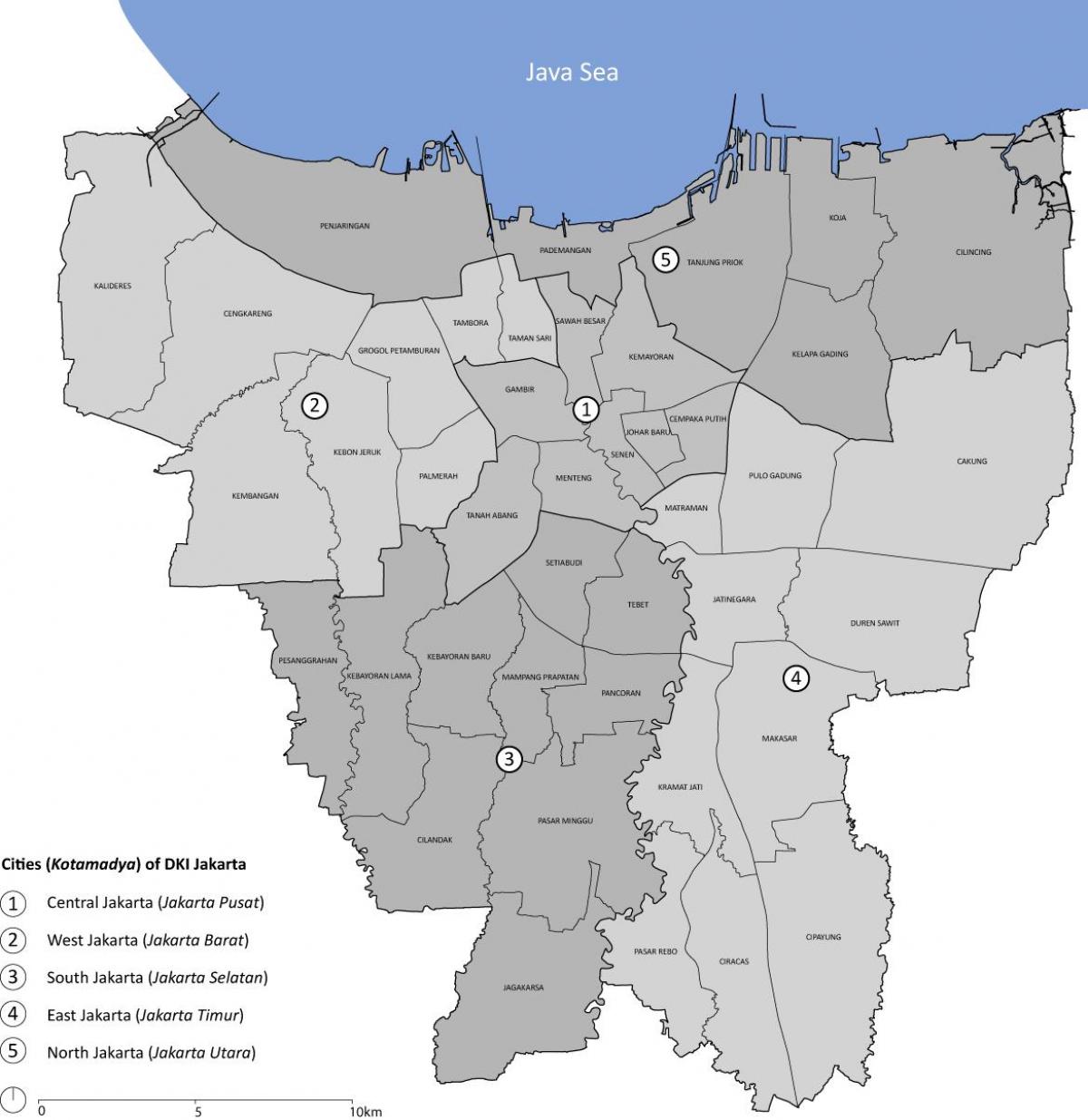
The Jakarta districts map shows all quarters and suburbs of Jakarta. This district map of Jakarta will allow you to discover areas and the region of Jakarta in Java - Indonesia. The Jakarta districts map is downloadable in PDF, printable and free.
This city of Jakarta is divided into 5 districts as you can see in Jakarta districts map, namely Jakarta Pusat, Jakarta Utara, Jakarta Barat, Jakarta Timur, and Jakarta Selatan. The term ‘Jabodetabek’ refers to Jakarta-Bogor-Depok-Tangerang-Bekasi - the Greater Jakarta area consists of megacities surrounding the capital. Other than the 5 municipalities, there is the thousand island regency which lies north of Jakarta bay. In the outskirts of the city; there are several suburban areas; outside the West is Tangerang, outside the South is Bogor, towards the Southwest is Depok, and outside the East is Bekasi and hence altogether formed a bigger area often called 'Jabodetabek'.
Jakarta Pusat or central Jakarta is where you can find the iconic landmarks such as Monas, The Merdeka Palace, The National Museum, Istiqlal Mosque, The Jakarta Cathedral, and Monumen Selamat Datang or the welcome monument widely renowned as Bunderan HI as its shown in Jakarta districts map. Some of the most prestigious shopping malls and upscale hotels are located right in the heart of Central Jakarta. Here you can enjoy the 24 hours excitements of Jakarta. Jakarta Utara or North Jakarta is where Taman Impian Jaya Ancol or Ancol Dreamland is located. It boasts a variety of amusements such as Dufan Theme park, Seaworld, Atlantis Water Adventure Park, Ecopark, an Art market and comfortable accommodation choices with a complete culinary destination. From Ancol Bay, you can hop on a boat and head to Jakarta pristine getaway, enriched with tropical islands named Kepulauan Seribu, or The Seribu Archipelago and sometimes also simply famous as The Thousand Islands.
Jakarta Barat or West Jakarta, Jakarta Timur or East Jakarta and Jakarta Selatan or South Jakarta as its mentioned in Jakarta districts map are those areas where a cluster of houses are located alongside offices, public facilities and more choices of shopping malls. In East Jakarta, you can visit Taman Mini Indonesia Indah, the miniature of Indonesia Archipelago. You can explore the details of traditional houses and a glimpse of Indonesia diverse culture in this park. When visiting South Jakarta, make sure to drop by at Setu Babakan and get to know the story of Betawi culture, the native ethnic group of Jakarta.