

You can find on this page the Jakarta map to print and to download in PDF. The Jakarta offline map presents the city center and the location in world map of Jakarta in Java - Indonesia.
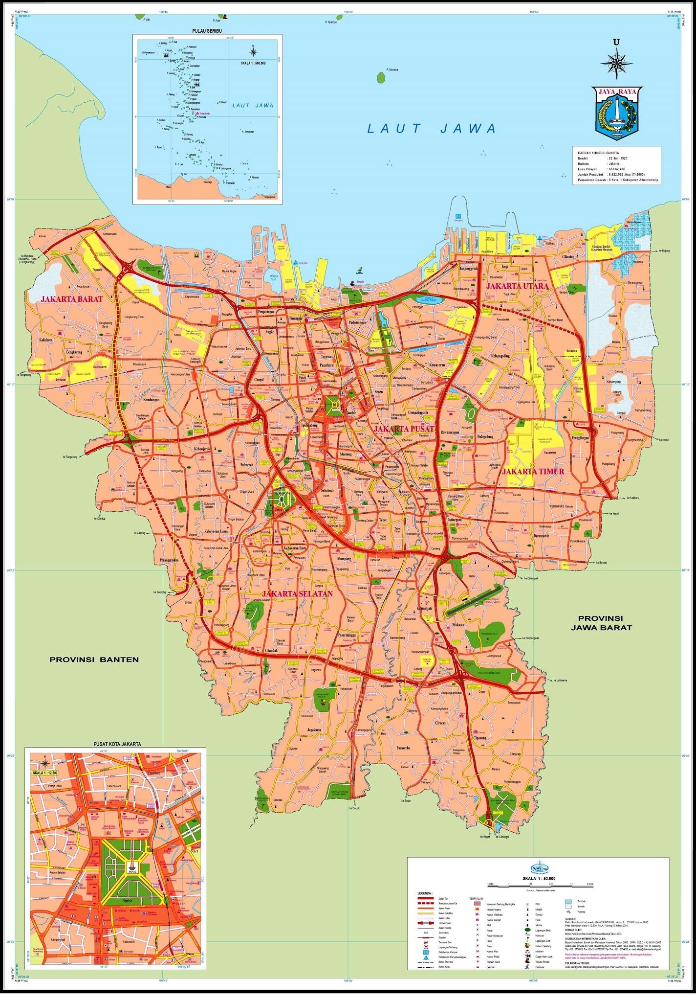
The Jakarta map shows the detailed map and a large map of Jakarta. This map of Jakarta will allow you to orient yourself in Jakarta in Java - Indonesia. The Jakarta map is downloadable in PDF, printable and free.
Established in the fourth century, the city became an important trading port for the Kingdom of Sunda. Jakarta was the de facto capital of the Dutch East Indies (when it was known as Batavia) and has continued as the capital of Indonesia since the country independence was declared in 1945. The city is the seat of the ASEAN Secretariat. Jakarta is served by the Soekarno-Hatta International Airport, Halim Perdanakusuma International Airport, and Tanjung Priok Harbour; it is connected by several intercity and commuter railways, and served by several bus lines running on reserved busways as its shown in Jakarta map.
The site which nowadays is referred to as Jakarta, has been home to multiple settlements along with their respective names: Sunda Kelapa (397–1527), Jayakarta (1527–1619), Batavia (1619–1949), and Djakarta (1949–1972). Its current name is derived from the word "Jayakarta". The origins of this word lie in the Old Javanese and thus ultimately in the Sanskrit language. "Jayakarta" translates as "victorious deed", "complete act", or "complete victory". Jakarta is nicknamed Big Durian, because the city is seen as the Indonesian equivalent of New York City (the Big Apple) as you can see in Jakarta map.
As the economic and political capital of Indonesia, Jakarta attracts many domestic immigrants who bring their various languages, dialects, foods and customs. The "Betawi" (Orang Betawi, or "people of Batavia") is a term used to describe the descendants of the people living in and around Batavia and recognized as an ethnic group from around the 18th–19th century. The Betawi people are mostly descended from various Southeast-Asian ethnic groups brought or attracted to Batavia to meet labor needs, and include people from different parts of Indonesia. The language and Betawi culture are distinct from those of the Sundanese or Javanese. The language is mostly based on the East Malay dialect and enriched by loan words from Dutch, Portuguese, Sundanese, Javanese, Chinese, and Arabic. Nowadays, the Jakarta dialect (Bahasa Jakarta), used as a street language by people in Jakarta, is loosely based on the Betawi language as its mentioned in Jakarta map.

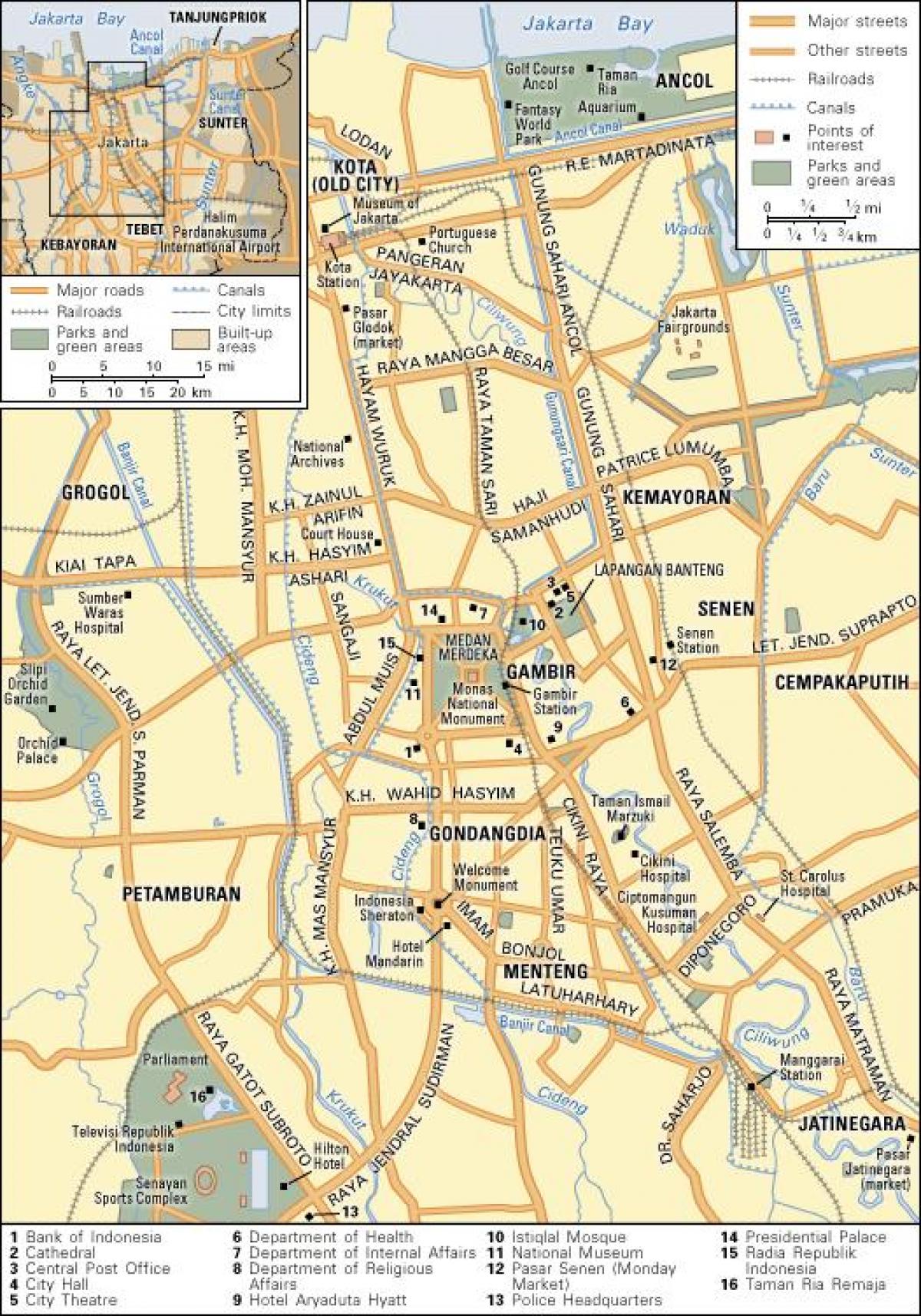
The map of downtown Jakarta shows the historical center of Jakarta. This downtown map of Jakarta will allow you to easily plan your visit in the center of Jakarta in Java - Indonesia. The Jakarta downtown map is downloadable in PDF, printable and free.
Central Jakarta ( Indonesian : Jakarta Pusat ) or Jakarta downtown is one of the five cities (kota) which form Jakarta , Indonesia . It had 898,883 inhabitants at the 2010 Census. Central Jakarta is the smallest in area and population of the five cities of Jakarta. It is the administrative and political center of Jakarta and Indonesia. Central Jakarta contains a number of large international hotels and major landmarks such as Hotel Indonesia. Central Jakarta is bounded by North Jakarta to the north, East Jakarta to the east, South Jakarta to the south, and West Jakarta to the west as its shown in Jakarta downtown map. Central Jakarta is divided into 8 Kecamatan ( Subdistrict ): Gambir, Tanah Abang, Menteng, Senen, Cempaka Putih, Johar baru, Kemayoran, Sawah besar.
Central Jakarta or downtown has an average of 19,000 residents per square kilometer, making it the most densely populated municipality in Jakarta as its mentioned in Jakarta downtown map. Both GRDP at current market price and GRDP at 2000 constant price in 2007 for Municipality of Central Jakarta is higher than other municipalities in DKI Jakarta, which is Rp. 145 million and Rp. 80 million respectively. At the end of the first quarter of 2010, the Jakarta CBD had an occupancy rate of 80%, an increase from the 78% at the end of the first quarter of 2009. According to Jones Lang LaSalle , the amount of office space in the Jakarta CBD increased by 93,000 square meters (1,000,000 sq ft) between the second half of 2010 and the second half of 2009.
In September 2010 Jones Lang LaSalle estimated that the Jakarta CBD had 30,000 square meters (320,000 sq ft) of serviced office space, making up less than 1 percent of the total amount of office space in the CBD. 70% of the tenants in the serviced spaces were international companies as you can see in Jakarta downtown map. The number of serviced office spaces in Central Jakarta increased by 50% in the year leading to September 2010. Government agencies with head offices in Central Jakarta include the National Search and Rescue Agency , which has its head office in Kemayoran.

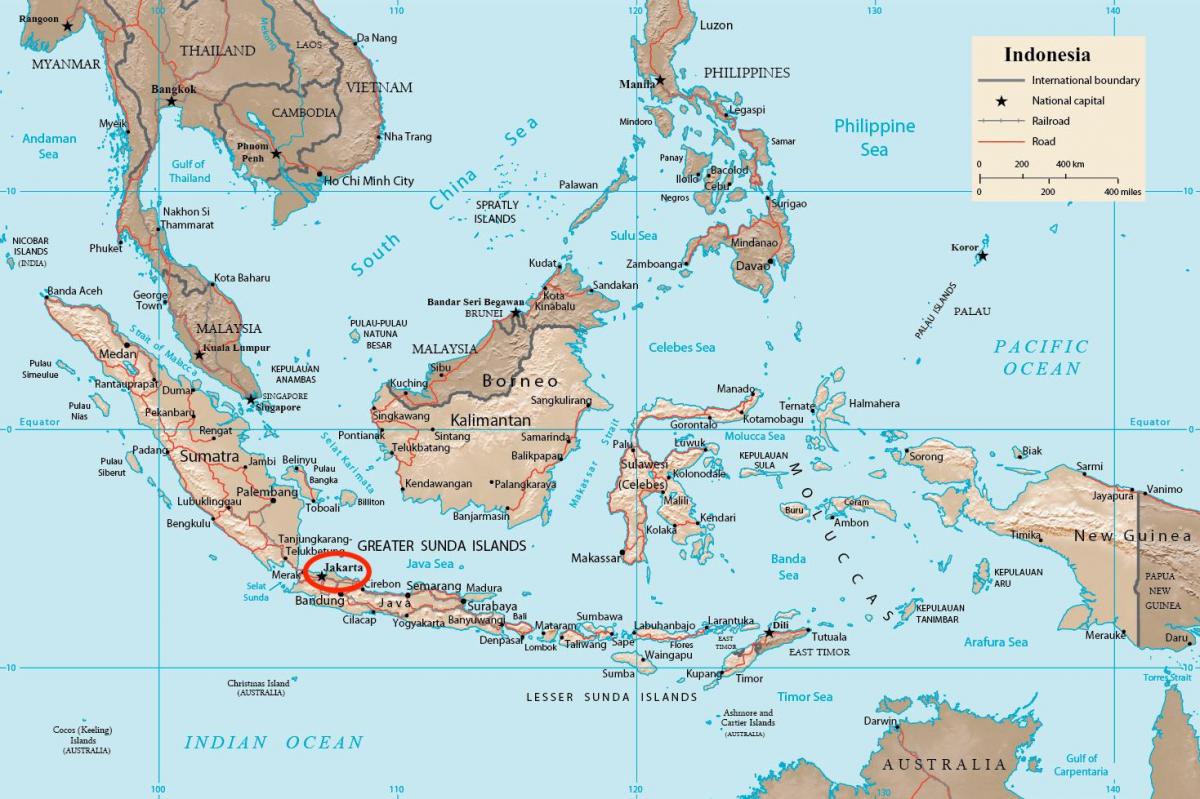
Jakarta on Java - Indonesia map shows the location of the city of Jakarta on the Java - Indonesia map. This map of Jakarta in Java - Indonesia will allow you to easily plan your travel in Jakarta in Java - Indonesia. Jakarta on map of Java - Indonesia is downloadable in PDF, printable and free.
Jakarta (play /dʒəˈkɑrtə/), officially known as the Special Capital Territory of Jakarta (Indonesian: Daerah Khusus Ibu Kota Jakarta), is the capital and largest city of Indonesia. Located on the northwest coast of Java as its shown in Jakarta Java - Indonesia map, Jakarta is the country economic, cultural and political centre, and with a population of 10,187,595 as of November 2011, it is the most populous city in Indonesia. Jakarta main seaport Tanjung Priok serves many ferry connections to different parts of Indonesia. Tanjung Priok is the largest seaport in Indonesia, with an annual traffic capacity of around 45 million tonnes of cargo and 4,000,000 TEU.
Soekarno-Hatta International Airport (CGK) is the main airport serving the greater Jakarta area as you can see in Jakarta Java - Indonesia map. The airport is named after the first President of Indonesia, Soekarno, and the first vice-president, Mohammad Hatta. The airport is often called Cengkareng or Soetta by Indonesians. The airport IATA code, CGK, originates from the name of the Cengkareng locality , a district situated to the northwest of the city. It is Indonesia busiest airport handling nearly 40 million passengers annually.
In 1974, Based on the Act No. 5 of 1974 relating to the Fundamentals of Regional Government, Jakarta was confirmed as the capital of Indonesia and one of Indonesia 26 provinces as its mentioned in Jakarta Java - Indonesia map. Much of the rioting targeted Chinese Indonesians. Suharto resigned as president, and Jakarta has remained the focal point of democratic change in Indonesia. Through the relationship with Prince Jayawikarta from the Sultanate of Banten, Dutch ships arrived in Jayakarta in 1596. In 1602, the English East India Company first voyage, commanded by Sir James Lancaster, arrived in Aceh and sailed on to Banten where they were allowed to build a trading post. This site became the center of English trade in Indonesia until 1682.

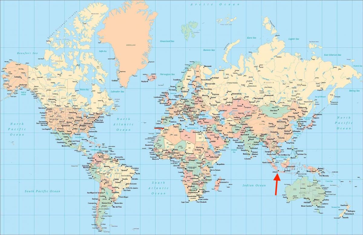
Jakarta on world map shows the location of the city of Jakarta in the world. Jakarta on world map will allow you to easily know where is Jakarta in the world. The Jakarta in world map is downloadable in PDF, printable and free.
The official metropolitan area, known as Jabodetabekjur, is the second largest in the world, yet the city suburbs still continue beyond it. Jakarta is listed as a global city in the 2008 Globalization and World Cities Study Group and Network (GaWC) research and has an area of 661 square kilometres (255 sq mi) as its shown in Jakarta on world map. Based on Brooking Institute survey about growth, in 2011 Jakarta ranked 17th among the world 200 largest cities, a significant jump from 2007 when Jakarta ranked 171st.
The 2010 census counted some 9.58 million people, well above all government estimates, Jakarta is the twelfth-largest city in the world. The area of DKI Jakarta is 662.33 km2, suggesting a population density of 14,464 people/km2 as the ninth largest urban population density in the world as you can see in Jakarta on world map. Inwards immigration tended to negate the effect of family planning programs. The population has risen from 1.2 million in 1960 to 8.8 million in 2004, counting only its legal residents. The population of Jakarta has increased dramatically since 1940. Much of that increase is attributed to immigration, which has transformed Jakarta into one of the world largest urban agglomerations.
A 2013 study by an Indonesian social media marketing agency noted that Jakartans are some of the world most active users of social sites like Twitter, LinkedIn, YouTube and Facebook. The Indonesian capital alone accounted for around 2.4% of the world 10.6 billion Twitter posts sent between January and March that year. Jakarta is one of the world cheapest cities, it has the worst traffic in the world as its mentioned in Jakarta on world map. As the business center of Indonesia, Jakarta is one of the world busiest and most crowded cities.