

You can find on this page the Jakarta metro map to print and to download in PDF. The Jakarta metro map presents the network, zones, stations and different lines of the metro of Jakarta in Java - Indonesia.
The Jakarta metro map shows all the stations and lines of the Jakarta metro. This metro map of Jakarta will allow you to easily plan your routes in the metro of Jakarta in Java - Indonesia. The Jakarta metro map is downloadable in PDF, printable and free.
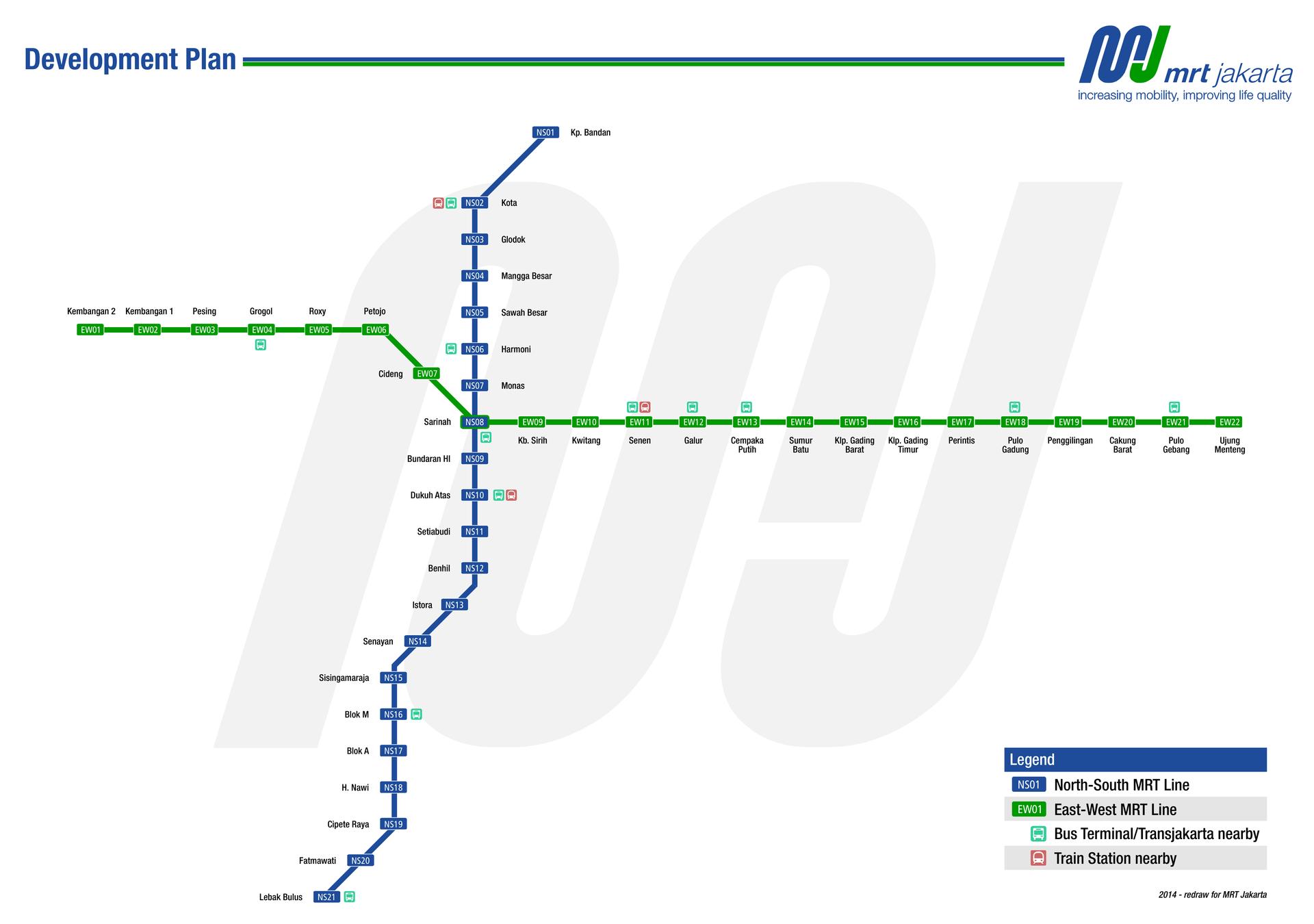
A two-line metro (MRT) system is proposed, with a north-south line between Kota and Lebak Bulus as you can see in Metro map Jakarta, without connections to the cancelled monorail lines; and an east-west line, which will connect to the north-south line at Sawah Besar Station. In the end the JMRT would be a combination of both subways and elevated rails. The metro system construction started in April 2012, with the first, 15.2 km-long line between Hotel Indonesia and Lebak Bulus, and the north-south line MRT network is scheduled to be operational by 2016. Jakarta Capital City Government had decided to build rail-based mass transits because this type of transport is capable of carrying passengers in large quantities quickly and cheaply.
The MRT is one of Jakarta biggest infrastructure developments that has also been long-awaited in the city. Although it has helped many people even during its opening in March 2019, construction is still undergoing for more routes to other locations. For now, Jakarta MRT has a North–South line between Kota and Lebak Bulus and an East–West line as its shown in Metro map Jakarta. It takes 30 minutes to reach one end to the other with the price ranging Rp 4,000 for each stop Rp 14,000. There are many ways to pay for the fare from single trip ticket (one way ticket), multi-trip ticket (multiple use card), Jaklingko (card for various transportations from TransJakarta, MikroTrans and MRT), Bank Electronic Cards (Flazz, Jakcard, Tapcash, e-money, Brizzi) or via the MRT app (Dana, Linkaja, Ovo, Gopay).
Jakarta had a well-established suburban rail network by the 1930s but this deteriorated in the post-war period and eventually closed in the mid-1960s as its mentioned in Metro map Jakarta. Japanese financial support helped to revive suburban services in the 1970s and these have since been modernised and expanded, providing Jakarta with the largest such network in Southeast Asia. Metro type systems came later – a monorail project was abandoned in 2008, but the construction of metro and LRT lines began in 2013 and 2016 respectively, with operations starting in 2019. The current three rail systems are separately owned and operated, offering only limited inter-connectivity, although a transport authority for Jabodetabek is planned to support further integration.
The Jakarta subway map shows all the stations and lines of the Jakarta subway. This subway map of Jakarta will allow you to easily plan your routes in the subway of Jakarta en Java - Indonesia. The Jakarta subway map is downloadable in PDF, printable and free.
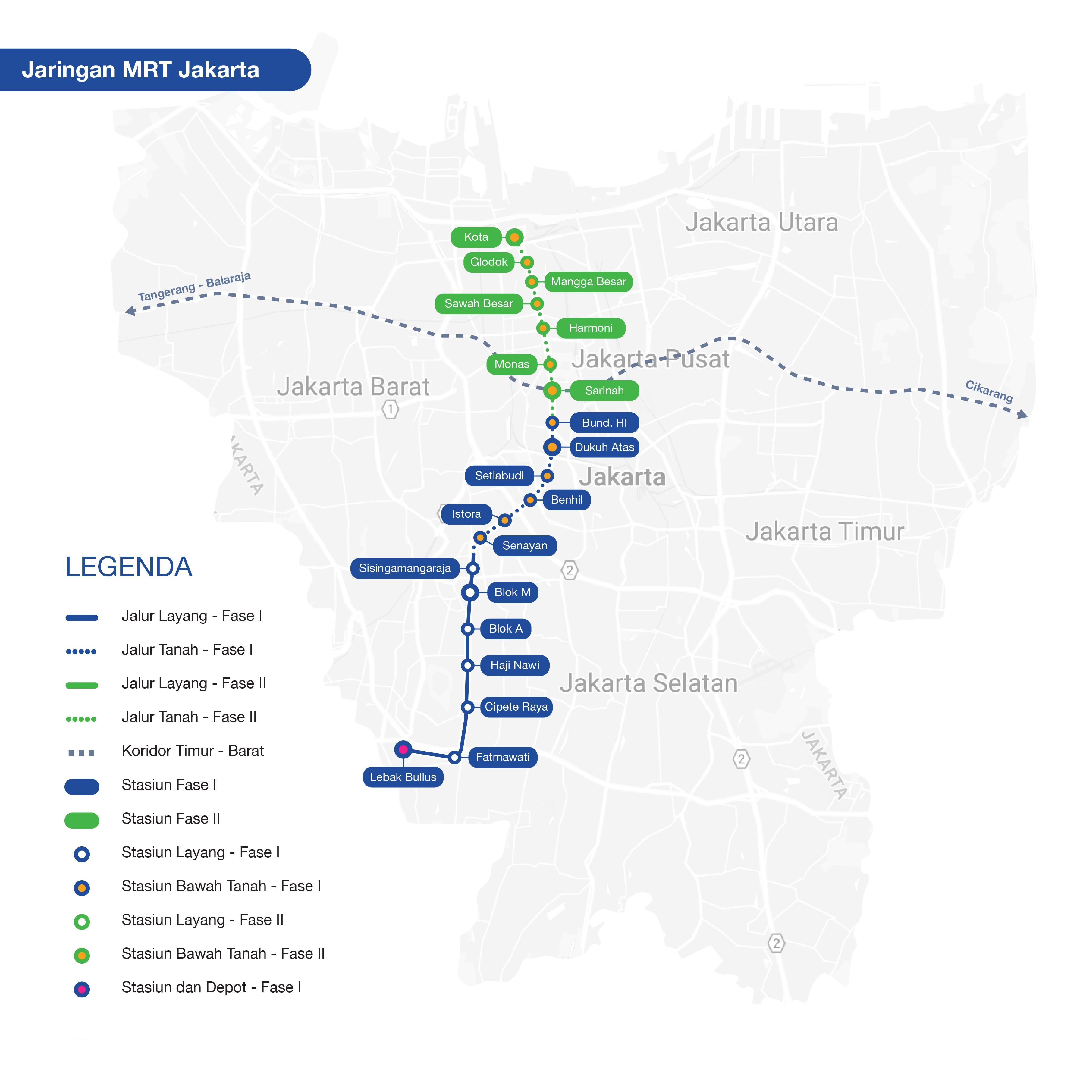
Jakarta Mass Rapid Transit (MRT) is a 20.1 km metro system with 1 line and 13 stations in Jakarta, Indonesia as you can see in Jakarta subway map. Phase 1 of the project (Lebak Bulus to Bundaran HI) was officially opened on 24 March 2019. Groundbreaking for Phase 2 was finally held on 24 March, 2019. As the Jakarta MRT map illustrates, there are a total of 13 MRT stations that are part of the North South Line. The 6 northern stations that are located in central Jakarta have been built underground. Therefore, you will either walk downstairs or take an escalator to access the MRT.
Currently, the two terminal stations on the North South Line of Jakarta MRT are Lebak Bulus Station (south Jakarta) and Bundaran HI Station (central Jakarta) as its shown in Jakarta subway map. When Phase II of the MRT development in Jakarta is completed, Bundaran HI will no longer be considered as a terminal station. Phase II of the MRT development will extend north beyond Kota Tua.
The Jakarta MRT will stretch across 110.8 kilometers as its mentioned in Jakarta subway map. This includes 23.8 kilometers for the North-South Corridor (Lebak Bulus – Kampung Bandan) and 87 kilometers for East-West Corridor. Japan International Cooperation Agency is funding the first phase of the Jakarta MRT which comprises seven elevated stations and six underground stations along 15.7 kilometers of the South-North Corridor from Lebak Bulus to Bunderan HI.